Kīlauea Eruption Status
ADVISORYLive Kīlauea eruption status & updates from the USGS Hawaiian Volcano Observatory. For informational & educational purposes only
📅 Kīlauea eruption status today: July 31, 2026
Source: USGS Kīlauea Volcano. All data from USGS/HVO. Not affiliated with USGS.
✉️ Eruption email alerts
One email when Kīlauea's status actually changes, nothing else. Unsubscribe anytime.
Also on the island right now:Mauna Kea tonight: fairVog: ModerateSurf: moderate on the east shore
🚨 Volcano Status
When is the next episode? Forecast window & pause pattern →
Volcano is showing signs of elevated unrest above known background levels.
Volcano is exhibiting signs of elevated unrest. Limited ash emissions possible.
USGS update: Friday, July 31, 2026, 9:06 AM HST
📋 Activity Summary
- ▸Kīlauea volcano is not erupting; summit eruption is paused
- ▸Reinflation indicates another episode (53) is likely
- ▸Preliminary forecast window for Episode 53: August 6–14
- ▸Episode 52 ended abruptly at 2:36 a.m. HST on July 29, 2026
- ▸Episode 52 had maximum lava fountain height of 500 feet
Full USGS analysis
The abrupt switch from summit deflation to inflation at the end of episode 52 along with glow from the vents indicates that episode 53 fountaining is likely. Preliminary tilt-based models have a forecast window for episode 52 from August 6 through August 14.Kīlauea has been erupting episodically since December 23, 2024, from two vents (north and south) in Halema‘uma‘u. Lava fountaining episodes, which generally last for less than 12 hours, are separated by pauses that can be longer than three weeks.HVO continues to closely monitor Kīlauea and is in contact with Hawai‘i Volcanoes National Park and the Hawai‘i County Civil Defense Agency about eruptive hazards.Please see the Hawaiʻi Volcanoes National Park website for visitor information: https://www.nps.gov/havo/index.htm Summary of episode 52:A detailed account of episode 52 is given in the HVO Status Report issued on July 29: https://volcanoes.usgs.gov/hans-public/notice/DOI-USGS-HVO-2026-07-29T13:10:51+00:00Episode 52 of the ongoing Halemaʻumaʻu eruption began around 7:10 p.m. HST on July 28 and ended abruptly at 2:36 a.m. HST on July 29, 2026.The maximum lava fountain height was approximately 500 feet (150 meters) above ground level from the north vent. The south vent never fountained during this episode but did emit flames at the end of the eruption. The maximum plume height was approximately 19,000 (5,800 meters) above mean sea level. Tephra fall was restricted mostly to the closed area of Hawaiʻi Volcanoes National Park to the southwest of the active Halemaʻumaʻu vents. Resources:NOTE: HVO’s monitoring network is mostly recovered from recent power- and storm-related outages. Several summit stations, including the SDH tiltmeter, will remain offline until we are able to re-establish access across the deep tephra field southwest of the caldera.The following links provide more information about the current eruption that began on December 23, 2024:Eruption resources, including the most recent map and a timeline of eruption episodes since December 23, 2024: https://www.usgs.gov/volcanoes/kilauea/science/eruption-informationShort messages tracking the evolution of the lava fountains and eruptive activity can be found here: https://www.usgs.gov/observatories/hvo/observatory-messagesThree Kīlauea summit livestream cameras that show eruptive lava fountains are available here: https://www.youtube.com/@usgs/streamsSummit eruption webcams: https://www.usgs.gov/volcanoes/kilauea/summit-webcamsVolcano Watch article on gas pistons: https://www.usgs.gov/observatories/hvo/news/volcano-watch-so-what-earth-or-least-kilauea-a-gas-piston Hazards:This episodic eruption is occurring within a closed area of Hawai'i Volcanoes National Park.Volcanic Gas: high levels of volcanic gas—primarily water vapor (H2O), carbon dioxide (CO2), and sulfur dioxide (SO2)—are continually released during an eruption. Emissions can remain locally hazardous in the areas immediately downwind of the vents, even when the vents are not actively erupting. SO2 reacts in the atmosphere to create vog (volcanic air pollution) downwind. SO2 and vog may cause respiratory and other problems at high concentrations. Further information on vog can be found at https://vog.ivhhn.org/Tephra: small glassy volcanic fragments—volcanic ash, pumice, scoria, Pele’s hair and reticulite—are created by the lava fountains. A combination of fountaining dynamics and wind conditions determines where tephra fall may occur for any given eruption episode. Larger particles fall near the vents while light particles may be wafted greater distances. These particles may be remobilized during windy conditions following recent eruptive episodes. Residents and visitors should minimize exposure to these fragments, which can cause skin, eye, and respiratory irritation. More information and guidance on tephra fall hazards is available at https://seagrant.soest.hawaii.edu/resource-and-guidance-for-volcanic-tephra-fall/Lava flows: lava on the floor of Halemaʻumaʻu crater and the southwest side of Kaluapele, Kīlauea's summit caldera, remains hot and may slowly move in the days immediately following an eruptive episode.Other significant hazards exist around Kīlauea caldera from Halemaʻumaʻu crater wall instability, ground cracking, and rockfalls that can be enhanced by earthquakes. Close to the eruptive vents, the tephra material on the crater rim is prone to cracking, slumping, and small landslides that sometimes expose hot and molten material within. This underscores the extremely hazardous nature of Kīlauea's caldera rim surrounding Halemaʻumaʻu crater, an area that has been closed to the public since late 2007.More Information:Kīlauea activity summary also available by phone: (808) 967-8862Kīlauea webcam images: https://www.usgs.gov/volcanoes/kilauea/webcamsKīlauea photos/video: https://www.usgs.gov/volcanoes/kilauea/photo-and-video-chronologyKīlauea lava-flow maps: https://www.usgs.gov/volcanoes/kilauea/mapsKīlauea FAQs: https://www.usgs.gov/volcanoes/kilauea/faqsThe Hawaiian Volcano Observatory is one of five volcano observatories within the U.S. Geological Survey and is responsible for monitoring volcanoes and earthquakes in Hawaiʻi and American Samoa. CONTACT INFORMATION: askHVO@usgs.govSubscribe to these messages: https://volcanoes.usgs.gov/vns2/Summary of volcanic hazards from eruptions: https://www.usgs.gov/observatories/hvo/hazardsRecent earthquakes in Hawaiʻi (map and list): https://www.usgs.gov/observatories/hvoExplanation of Volcano Alert Levels and Aviation Color Codes: https://www.usgs.gov/programs/VHP/volcanic-alert-levels-characterize-conditions-us-volcanoes
📐 Summit Tilt: Past 3 Months
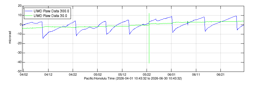
What is tilt? Electronic tiltmeters measure tiny changes in the slope of the ground near the volcano's summit. Think of it like a very sensitive carpenter's level. → Learn more about tilt monitoring
Why it matters: When magma moves into the reservoir beneath the summit, the ground inflates (tilts upward). Rapid inflation often precedes eruption episodes. Deflation during eruption shows magma leaving the reservoir. The pattern of inflation → eruption → deflation repeats with each fountaining episode.
Source: USGS Monitoring Data
📷 Summit Webcam

V1cam: West Halemaʻumaʻu crater. Image refreshes periodically at source.
Source: USGS Webcams
📷 View all live webcams →🏞️ Park Access & Lava Viewing
No active lava at the summit right now
The National Park Service currently lists 4 closures in the park. Check the closure list before you set out, as closures can affect which overlooks and trails are reachable.
📊 Timeline of Eruptive Episodes
| # | Start (HST) | Pause (HST) | Duration | Pause After | Height (m) | Vol (Mm³) |
|---|---|---|---|---|---|---|
| 52 | July 28, 2026 - 7:10 p.m. | July 29, 2026 - 2:36 a.m. | 7 hours | TBD | 150 | 4.7 |
| 51 | July 15, 2026 - 8:30 a.m. | July 15, 2026 - 4:46 p.m. | 8 hours | 13 days | 290 | 5.1 |
| 50 | June 27, 2026 - 10:10 a.m. | June 27, 2026 - 5:10 p.m. | 7 hours | 18 days | 300 | 4.9 |
| 49 | June 14, 2026 - 9:36 a.m. | June 14, 2026 - 5:05 p.m. | 7.5 hours | 13 days | 210 | 5 |
| 48 | June 1, 2026 - 4:40 a.m. | June 1, 2026 - 1:37 p.m. | 9 hours | 13 days | 200 | 5.7 |
| 47 | May 14, 2026 - 3:27 p.m. | May 15, 2026 - 12:27 a.m. | 9 hours | 17 days | 200 | 5.2 |
| 46 | May 5, 2026 - 8:17 a.m. | May 5, 2026 - 5:22 p.m. | 9 hours | 9 days | 200 | 4.6 |
| 45 | April 23, 2026 - 1:34 a.m. | April 23, 2026 - 10:01 a.m. | 8.5 hours | 12 days | 265 | 5.2 |
| 44 | April 9, 2026 - 11:10 a.m. | April 9, 2026 - 7:41 p.m. | 8.5 hours | 13 days | 240 | 5.8 |
| 43 | March 10, 2026 - 9:17 a.m. | March 10, 2026 - 6:21 p.m. | 9 hours | 30 days | 540 | 11.9 |
See every episode with fountain heights, volumes, and rankings →
Source: USGS Eruption Information. All times HST. Data preliminary and subject to revision.
❓ Frequently Asked Questions
When is the next Kīlauea eruption?
Kīlauea is not erupting right now. The Halemaʻumaʻu eruption is paused between episodes. USGS forecasts Episode 53 for August 6 – 14, roughly 5 days from now. Scientists estimate these windows by tracking summit tilt, seismicity, and GPS ground deformation. The live forecast module above updates every 5 minutes from USGS HVO data.
Learn about eruptions, planning a visit, safety, and more
View FAQ →🗺️ Best Viewing Area
During an eruption, lava is visible from designated overlooks along Crater Rim Drive. The park guide compares each one: what it sees, how far you walk, and where to park.
📍 See the overlook guide: map, walking distances & parking →The summit fogs in often. When the camera frame is blank white, the overlooks look about the same in person. Check the Uēkahuna camera before you drive up →
A clear night here is also a Mauna Kea night. Check tonight's stargazing conditions →
The vog on the Big Island comes from this eruption. See today's air quality by town →
Getting in the water on this trip? Big Island surf by shore and beach advisories →